|
The area of Cranbury in the early eighteenth century
may be described as a geographical region, which encompassed in part
present-day Monroe Township. For example, the names of Freehold, Crosswicks, Brunswick, and Perth Amboy, all at that time
referred to much larger areas than those which are now associated with those places. The nearest settlements to Cranbury in
the 1740s included South River Bridge, Brunswick, Windsor, and Princeton.
The exact location of Bethel has been the source of inquiry
since the nineteenth century when biographers of David and John Brainerd sought advice of local residents of Middlesex County.
In his 1866 biography of John, Thomas Brainerd (a relation) included a letter from the minister of the Cranbury Presbyterian
Church, who wrote that the traditional location of Bethel was two miles northeast of Cranbury, off the Georges Road. This
description would put it in present-day South Brunswick Township, near the Cranbury Township border. There is no documentary
evidence, however, to place Bethel in this location.
Likewise, there is oral tradition in the Jamesburg area that
a grove used for picnics in the late nineteenth century was the site of Bethel. This tradition does come geographically closer
as the grove was located on land owned for seven years by John Brainerd, and subsequently purchased by Peter Deriemer and
later by Alexander Redmond. Redmond was a source of information related to Bethel for the author of an 1882 history of Middlesex
County, whose property included the site of Bethel.
The historical record, both primary and secondary, does provide
the likely site of Bethel, though physical evidence may rest on future archaeological investigation. Historical references
clearly indicate where Bethel once stood.
The first piece of evidence is from James Blain’s complaint
in 1746 that David Brainerd was about to settle three hundred Indians on the John Falconer tract. John Falconer was son of
David Falconer, who had acquired several tracts of land from the East Jersey Proprietors in the late seventeenth century.
Neither David or John Falconer settled in New Jersey, and left the management and sale of their lands to others. A portion
of Falconer’s tract was sold to Eliphelett Frazie of Elizabethtown, New Jersey in 1700. Never settled upon, this land
passed ultimately to Peter DeReimer in 1754. In 1733, the majority of David Falconer’s tract along the Manalapan
was offered for sale by James Alexander, but there is no record of it being sold.
The Falconer Tract as described in the original deed of 1689
from Robert Barclay to Falconer, and also reiterated in the 1733 newspaper advertisement was as follows:
500 Acres of Land on Menalapan River, in the County of Middlesex,
in New-Jersey, beginning at the Mouth of Island Brook on the said River, and running West Forty Chains, thence South Ninety
six Chains, and thence East Thirty five Chains to a Run of Water, and thence down the Run to the River, and thence as the
Stream runs to where it first began; which Tract, amongst others, was patented to Robert Barclay the 22 of January, 1689,
and conveyed to David Falconer by Deed recorded in the Secretary’s Office at Perth Amboy, Lib. H. fo. 3. [New Jersey
State Archives, Book H, p. 3]
A second piece of evidence, although less direct, was purchase
of land by John Brainerd and Ebenezer Hayward, both identified as being of Bethel, at a point bordering the Falconer tract
as noted above.
Another indication as to the vicinity of Bethel comes from
Rev. William Tennent’s description of his work there. In his 1756 report to the Society, he described Bethel as being
between seven to eight miles from his church. This is exactly the distance, using the eighteenth century roadways, from Old
Tennent to Thompson Park, Monroe Township.
The forth piece of important evidence is the 1758 reference
from the Crosswick’s Conference that references the Indian settlement on the Manalapan River, in "Falkner’s tract."
Falconer did not own any land situated in South Brunswick or Cranbury Townships, nor can there be any doubt as to the reference
of the Manalapan River.
Another historical reference comes from surveys made by the
Board of Proprietors for East Jersey. In two separate surveys made for Thomas Leonard (possible brother of Captain John Leonard
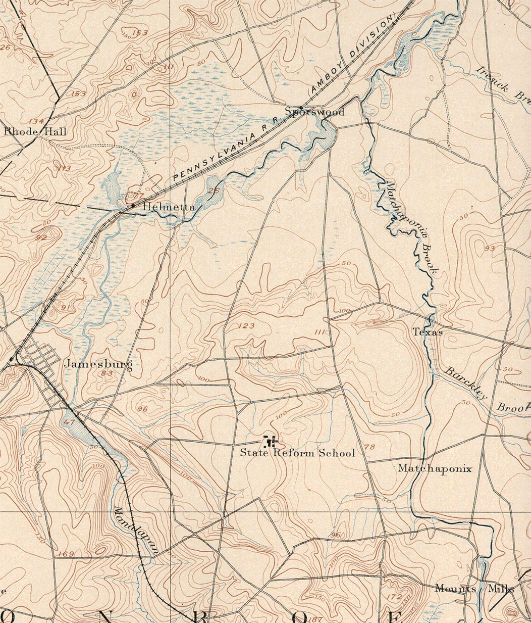
killed by Weequehela), boundaries are referenced to the "public road that leads from Col. Andrew Johnston’s Mill to
the Indian Town." Johnston’s mill was situated in Spotswood, New Jersey, just east of Monroe
Township.
Moving
forward into the nineteenth century, Alexander Redmond, whose property had passed from John Brainerd to
Peter Deriemer in 1754, stated that Wigwam Brook had its source in springs located in the Indian settlement of Bethel. Wigwam
Brook begins at what is now the present-day intersection of Perrineville Road and Schoolhouse Lane in Monroe Township, Middlesex
County. It flows northerly towards the Jamesburg border, and then disappears into a culvert which empties into the Manalapan.
A portion of the boundary of Brainerd’s property followed a substantial length of Wigwam Brook.
The west side of the Manalapan River, at the time of
Clayton’s research, was known as the Faulkner tract, and as late as 1758 was inhabited mostly by Indians. "When Alexander
Redmond purchased the property in 1841 many cellars, showing the former location of houses in the Brainerd settlement, were
visible, and he long retained stones that had been used as hearths, as well as many relics of the Indians exhumed there."
The oral tradition of Bethel’s site continued well into the twentieth century. "The tradition had long been handed down,
Jim Vandenbergh said, that there was an ‘Indian city’ about a mile and a half from the village [Jamesburg]."
To locate Bethel on the ground requires knowledge of
the Manalapan and the tributaries mentioned in the historical record. Island Brook is repeated in all of the deeds and mortgages
as the starting point for both the Falconer Tract, and the parcel acquired by Brainerd and ultimately acquired by Alexander
Redmond in the early nineteenth century. But locating Island Brook today based on maps and points of reference in usage today
is impossible. The name of the stream has disappeared over the centuries, and repeated attempts to locate it through municipal,
county and state sources, as well as geographical and water-resource data, proved fruitless.
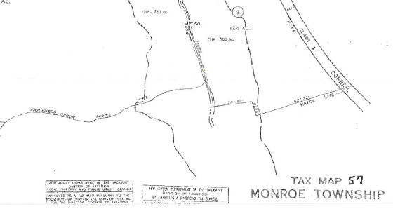
Without an exact match to Island Brook, all efforts
to map the Falconer Tract and Brainerd parcel could not be exact. Fortunately, current tax maps of Monroe Township depict
a stream in the vicinity still identified as Faulkner’s Brook. This is the exact location of the unnamed run of water
mentioned in Falconer’s deed and subsequent 1733 advertisement, and is the exact distance to a stream entering the Manalapan
in present-day Thompson Park in Monroe. This latter stream is Island Brook, which is proved by both matching the Falconer
boundaries, the Brainerd boundaries, and verified by Redmond’s description of the late nineteenth century.
Today the site of the Bethel Indian Town remains an
open public space. It is currently part of Thompson Park in Monroe Township, near the intersection of Schoolhouse Lane and
Perrineville Road. The streambed of Wigwam Brook is discernable in the expansive lawn adjoining soccer fields. Whatever the
future holds for the site, evidence suggests archaeological surveys could uncover a long lost piece of New Jersey and Delaware
Indian history.
| Monroe Tax Map that still shows Faulkners Brook |
|
|
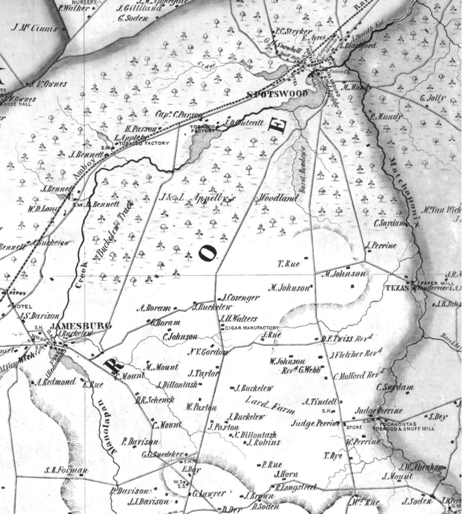
| 1850 map of area. Bethel was situated near the intersection of the two roads at the bottom left. |
Weequehela's plantation and mills were located just south of Spotswood, to the west of the stream at Burnt Meadows.
He was an important sachem of his people but was unjustly tried and executed in 1727 by colonial authorities. His successor,
Andrew Woolley, and others, sold the remaining Manalapan lands at Spotswood to the Johnston brothers in 1739, thus transferring
the famous millseat that was to become Spotswood.
|